New Forest Remembers – Park Farm post-excavation update

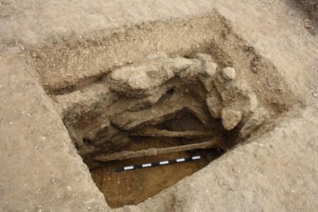
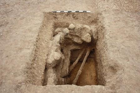
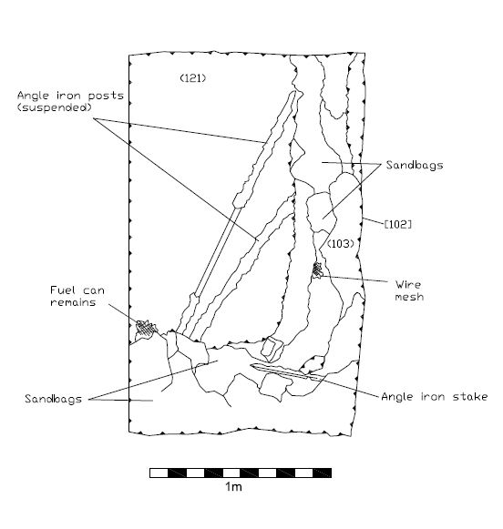
As part of the post-excavation process, Bournemouth Archaeology staff have been digitising the archaeological drawings from the Park Farm site using AutoCAD software.  To give an insight into how this is done, we have selected a gun pit feature which one of the project volunteers, Tim Wilding, did an excellent job of recording. In this blog entry you will see how we take the original drawings, scan them and then utilise the resultant digital files to trace all recorded features, which ultimately will be used to create a series of figures for the final report.


Below you see a selection of the photographs which were taken as part of the recording process on site, in addition to the scale drawing itself.

 IMG_3349 Gunpit feature IMG_3340 Gunpit feature

P1000539 P1000541

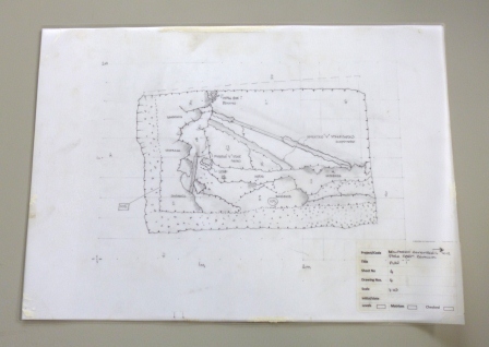
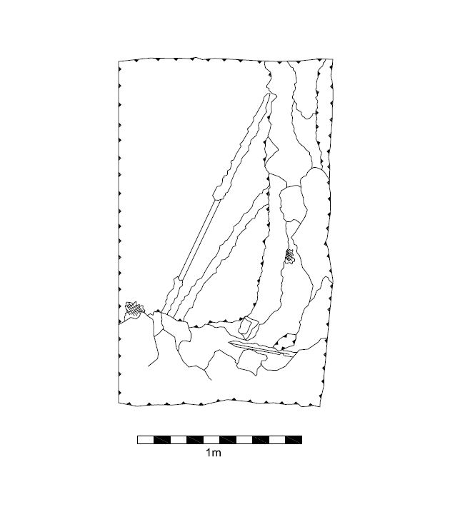
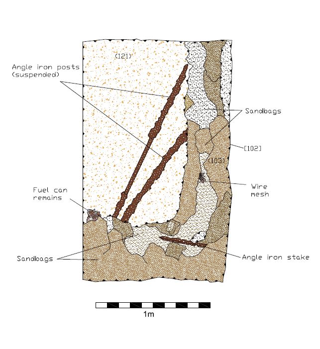
Once the original drawing has been scanned, the digital version is opened in AutoCAD software and scaled accordingly. From this point we are able to trace an overlay of the plan and section drawings for each feature and then manipulate the digital file as required. This includes adding necessary annotation, orienting the feature correctly and adding different layers of detail, which can be turned on and off as needed.
 Gun pit feature plain Gun pit feature annotatedGun pit feature hatch

Staff at the New Forest National Park Authority were also able to create a fully rotatable 3D image of the gun pit feature by collating together the digital photographs which were taken during the recording process and using specialist software to combine them into a 3D mesh. This pdf file is available for viewing and download below.


Gun pit feature 3D image

New Forest Remembers – Park Farm Dig, Hampshire

During the month of July, Bournemouth Archaeology was involved in an exciting Festival of British Archaeology project in collaboration with the New Forest National Park Authority as part of their wider Heritage Lottery Funded ‘New Forest Remembers – Untold Stories of World War II’ project. This project was established in 2012 to address the lack of survey work, knowledge and understanding about the New Forest’s role in World War II.

Working alongside a number of keen volunteer members of the public, we have been engaged in the excavation and geophysical survey of features relating to a WWII anti-aircraft gun battery; part of the Needs Oar Point advanced landing ground at Park Farm on the Beaulieu Estate. The airfield and associated features were returned back to farmland in 1945, which included backfilling subterranean features, such as the gun emplacements, with a bulldozer.

Although the gun emplacements are now invisible on the ground surface they do show up in aerial photographs as crop marks, along with a large pre-WWII square-shaped enclosure immediately adjacent to the gun battery, which we also took the opportunity to investigate in some of our trenches.

Over the course of the project, the enthusiastic and knowledgeable volunteers participated in a range of activities including metal detector prospection, used to locate small sub-surface finds, and played a key role in helping to identify the artefacts we uncovered, including: regimental buttons, eating utensils, spent ammunition and artillery shell fuse covers. They also got stuck in with their mattocks and trowels, revealing evidence of the more substantial features at the site, which they were then able to record.

On Saturday 20th July, a delegation of volunteers from the Young Archaeologists Club, Southampton, also paid a visit to the site and spent the day joining in with the metal detecting, excavation and finds processing. It was great to have so many enthusiastic young archaeologists eager to get involved.

In addition to all the hardworking volunteers who took part, Bournemouth Archaeology would also like to thank Frank Green,  James Brown, Lawrence Shaw and Gareth Owen who represented the project on behalf of the National Park Authority.

Now that we have decamped from site, the process of processing the accumulated data and finds in preparation for the creation of a report has begun.

Be sure to check back for follow-up blog entries over the coming weeks.

Bournemouth Archaeology and the Renewable Energy Sector

This week the Bournemouth Archaeology team, all kitted out in our new branded polo shirts, attended the RegenSW Bournemouth Renewable Energy Marketplace at Bournemouth’s International Centre, the biggest renewable energy exhibition and conference in south England.

Like any development, the construction of renewable energy infrastructure can be impacted on by the presence of archaeology, so we appreciated the opportunity to network with some of the biggest renewable energy providers in the UK, and explain how we can use our expertise to both reduce risk and avoid unnecessary cost to their projects.

Our team manned a stand and answered enquiries regarding the need to consider the impact of extant archaeology for proposed renewable energy development projects. Having provided pre-planning advice to our clients and undertaken a number of mitigation projects, we have developed a thorough understanding of the importance of considering heritage when it comes to planning these developments.

We have provided advice to clients on retrofitting renewable energy systems to their historic and listed buildings and potential impact on historic fabric. We have also provided pre-planning advice to clients who are looking to develop land for large ground-mounted solar photovoltaic systems and wind farms, and carried out geophysical surveys, evaluations, excavations and watching briefs to help them reduce their risk and reduce their costs in dealing with archaeological and heritage issues. One such project we have worked on this year was covered in an earlier blog post.

Bournemouth archaeology is always actively seeking to partner with renewable energy consultancies and providers to deliver heritage advice in the early planning stages of projects and thereby ensure that the highest levels of heritage protection and mitigation can be achieved.  The RegenSW Bournemouth Renewable Energy Marketplace was therefore a great opportunity to meet some new contacts in the exciting renewable energy sector, and our team thoroughly enjoyed talking to and learning from the other exhibitors and event visitors.

Thanks to all who attended and stopped by to ask us about our services. We look forward to hopefully working with some of you soon.


Cerne Abbas Archaeological Investigations Project, Dorset

Over a very wet and cold winter Bournemouth Archaeology has been working on a geophysical survey in Cerne Abbas, Dorset, on the supposed site of the Benedictine Abbey around which the village grew.

Following liaison with English Heritage and the granting of a Section 42 licence our geophysical survey team have been carrying out a magnetometer survey, using Bartington Grad 601-2 fluxgate gradiometers, and a resistivity survey over the same area with the Geoscan RM15-D Resistance Meter. The exact location of the Abbey is unknown and today all that remains are the Guesthouse, Abbey Barn, and Abbot’s Porch. The main focus therefore was to survey a plot of land to the immediate east of the Abbot’s Porch, north of a small cemetery, where some evidence might exist.

The Abbey at Cerne Abbas was founded in AD 987 and became a significant landowner, dominating the area for more than 500 years. However, in 1539 the Abbey surrendered to Henry VIII and was mostly destroyed; the Abbey lands subsequently passing into private ownership. The Abbey itself fell in to ruin and was probably used as a quarry for building material. Using a little detective survey work it is still possible to find some recognisable fragments of the Abbey which have been re-used in the construction of houses and other buildings around the village.

So far the survey results have been very encouraging.  By overlaying the results from both geophysical techniques we have been able to identify a number of anomalies which may prove that some sub-surface evidence of wall foundations do indeed survive. Following consent from English Heritage, and working alongside Cerne Abbas Historical Society, the next phase of the project will be to excavate a number of test pits to try to locate the foundations and start to map the layout of the Abbey.


Bournemouth Archaeology Project Manager Jonny Monteith will be giving a talk on the results of the survey and the next phase of the investigations to Cerne Abbas Historical Society on the evening of 28th March.


Find out more about our services here.

Recent work in the Bournemouth Archaeology post-excavation department

The busy start to the year means there is currently a lot going on in Bournemouth Archaeology’s post-excavation department. The spacious and well-equipped laboratory facilities at Bournemouth University are ideal for processing and analysing the different types of material brought back from archaeological fieldwork projects; from environmental samples, human remains, fragile items with specific conservation requirements to the more familiar bags of animal bones and pottery.

We use artefacts to date sites and tell us about their status and function. Often the most unassuming fragment of pottery can yield important information, especially if nothing else has been found. We are currently processing artefacts from a number of sites, and our trays contain a fascinating range of material culture, from Bronze Age struck flints to Roman pottery, an early 20th century cigarette packet and even a letter post-dated 1965. These last two artefacts have come from a historic building recording project, and although modern in comparison to the material we are used to dealing with they will help to date the many modifications the particular building has gone through during its lifetime.

Environmental samples provide a wealth of information. Bulk samples from excavations are the most common form of sample being dealt with by the department at any particular time. These samples are processed in flotation tanks; the flots (everything that floats – such as charred plant remains) and residues (everything else suspended in the soil – stones, snails and artefacts) can then be analysed to see what they contain. We have just started looking at some very interesting flots recovered from an Iron Age site near Bicester. The charred seeds and cereal grains which can be seen amongst the charcoal will be separated out and identified to tell us what was being grown and consumed on the site.